GPSMaster is gps mapping software that runs under Windows on a PC and is able to communicate (serial or USB) with any Garmin GPS. You can download all the desired data from your GPS, edit it, save it, view it, print it, upload it. When you use your GPS regularly GPSMaster is a must have!
GPSMaster is ideal for pilots, sailors, cyclists, hikers, basically anyone who enjoys outdoor activities. When you go on holiday to a place you've never been before, just get yourself a map of the particular area, scan it, load it into GPSMaster, calibrate it and you're ready to go. You can create waypoints, routes and tracks based on your scanned map and send them to your GPS.
Main features:
- Transfer of waypoints, routes and tracks between GPSMaster and your (Garmin) GPS (other brands of GPS's may me implemented in the near future) over serial port or USB.
- Creation of waypoints, routes and tracks in GPSMaster
- 222 Map datums including user definable map datum
- Latitude/Longitude, UTM, British National Grid, Irish Grid, Dutch Grid, Swiss Grid and user definable grid (others will be implemented in the near future)
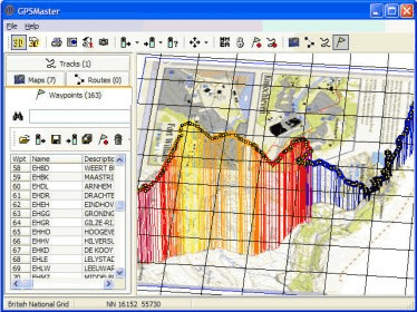
- Drawing of all grids in all projections (so not just displaying a coordinate in eg British National Grid, but also the actual drawing of the grid !)
- Feet/Statute Miles/Nautical Miles/Meters/Kilometers
- Map projection, Spherical projection, Sinusoidal projection, Eckert VI projection and McBryde-Thomas Flat-Polar Sinusoidal projection
- Auto Aspect in Map projection
- 3D Viewing !
- Easy zooming using mouse wheel
- Great Circle Navigation and Rhumbline Navigation
- Editing of tracks (deleting points, moving points, moving whole track, changing color)
- Graphs of track altitude/speed/vertical speed, with variable x-axis (time, distance, points)
- Add pictures to your waypoint
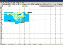
- Use your own scanned maps, just calibrate them (in any grid and any map datum) and you're ready to go !
- Intuitive user interface
- NMEA0183 support following sentences are supported (GPBOD, GPGGA, GPGLL, GPGSA, GPGSV, GPRMB, GPRMC, GPRTE, GPWPL, HCHDG, PGRME and PGRMZ)
- Graphical display of NMEA heading, distance
- Creating of waypoint from NMEA input
- Recording of NMEA input to track
- Creation of screenshots
- Printing of screen
- Full control over visualization (lots of color and line width settings, user selectable font etc.)
- User-definable hints when mouse hovers above waypoints/track
- Very easy distance measuring including display of great circle course or rhumbline course
- Autogrid
- Very easy zoom and fit functionality
- Imports PCX5 andOziExplorer files
- Imports tracks in gpx format
- Supports every Garmin GPS

An application for planning routes & managing routes, waypoints and trackpoints.


Comments (7)